
The lesson here is clear: follow unpaved roads, and look for light.
(clicking on images makes them large. Recommended.)


The lesson here is clear: follow unpaved roads, and look for light.
(clicking on images makes them large. Recommended.)
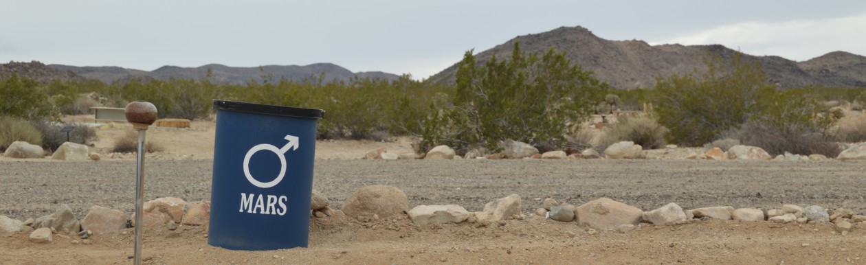
While staying with my cousin James and his lovely family, we declared that since it was Sunday, we had to go for a hike. It was the last day of our vacation, we were meant to fly out that night and it was predicted to hover near 100 or above all day. For these reasons we decided not to go to Red Rocks just outside of town, but rather for a more leisurely stroll around Tule Springs Ranch, a park constructed around a former “Divorce Ranch.”
Fro the 30’s until the 1950’s you could only get quick and easy divorces in certain states, and the ever enterprising Nevada was one of them. But, of-course, you had to establish residency, which took six weks. During that time, women would sometimes stay at a Divorce Ranch. You can read all about the craziness in this article at Slate, but the gist was: “… a typical day at a divorce ranch might have looked like this: horseback riding in the morning, an after-lunch trip into town for shopping or a visit with a lawyer, and then, in the evening, cocktails, communal dinner, and another car trip to a bar or a casino, where the ladies would dance and drink and gamble.”
People, I have gotten a divorce and I say “hells yes!” to the divorce ranch. Six weeks to cool my heels, ride horses, drink, gamble, and perhaps have a dalliance with a handsome cowboy, that would have really eased the transition I think.
In any case, the grounds were lovely, Ivan chased Peacocks and collected feathers, the kids played with their kid-cousins and we all got pretty hot under the Nevada sun. We followed it up with a walk around a bird and animal sanctuary, and then quickly sought out air conditioning and shade.


Zion National Park. It was named Zion by an early Mormon settler who regarded that one could worship as well in this cathedral in any on earth. The name that had previously been attributed was Mukuntuweap, a Paiute word which is roughly translated as “straight valley.” I’m partial to the Mormon name, surprisingly. It suits the place.
The Zion Canyon floor is a shocking, fertile green basin at the base of a jumble of mountains that huddle around it like a protective fortress. It’s the meeting point of three major geographical areas: the Great Basin to the West, the Mojave to the Southwest, and the Colorado Plateau to the East. Subsequently, it is a wild looking place. Wild in the sense of being untamed, untamable – and wild in the sense that it’s singularity causes one to stand gobsmacked on the canyon floor with their mouth hanging open.
As a National Park, Zion is an impressive operation. Most of the trails are accessible via a system of park shuttles, so as to keep the nearly 3 million annual visitors from clogging the canyon with their rented RVs. Adam noted that the amount of love and dedication it would take to make a place like this accessible is truly astounding, and I agree. There is a vast wilderness and back-country in Zion that I’ll never know, but truly, I’m just grateful for the chance to enter the temple, as it were.
The east side of the park is accessible only via a one-mile, unlit, two-lane tunnel with no shoulder. One arrives at this tunnel by a series of switchbacks that snake impressively up a canyon wall gaining about 600 feet in 5 minutes. I was surprised to find that I had a white-knuckle fear of such roads. Adam was driving, but he was also so completely awed by the scenery he would lean forward in his seat and peer upward out the windshield, instead of IN FRONT OF THE CAR on the spectacularly curvy road. In a move that might be familiar to many road-tripping couples there was an abrupt turn-off along the road followed by the invective, “YOU DRIVE”, and a huffy me adjusting seat and mirrors and taking us through the horrifying tunnel and across to the east side of the park for a hike.
The Canyon Overlook trailhead is just past the tunnel, and as we laced up I watched the sky gathering clouds and frowned. We started on the trail, which is almost completely uphill, with Adam in the lead, the kids in the middle, and me following behind. If I try to remember the hike all I remember is my own accelerated breathing, and the image of Ivan’s heels on sand covered rock (extremely slippery!!), on a ledge approximately a billion feet from the ground. With each step my need to vomit increased. All around families passed me, toddlers (TODDLERS!) passed me, happily confident that they wouldn’t plummet to their death. After ten minutes I shouted to Adam, “I can’t do it! It’s not fun! I hate it!” Everyone assured me it was ok, and Ivan came back to the car with me since he was feeling tired anyway, leaving Adam and Veronica to sally forth.
Ivan waited in the car and played on my phone while I paced and watched the sky with mounting anxiety. When I heard thunder, I actually simpered. I was so disappointed with myself. Where was the carefree adventurer of my youth? I can only surmise she disappeared when I had children. I think if it had just been me, I could have grimaced through it, but my nervousness with the kids would only have made it a misery for everyone. Finally Adam and V. came bounding off the trail, Adam ecstatic, Veronica flush with the cool air and sense of achievement. She was beaming and mugging with Adam about their daring little expedition, the happiest I had seen her in days.
We headed back down canyon and spent the rest of the drizzly afternoon in Springdale picking out the perfect rocks to lug home in our suitcases. We had been told to go to Oscar’s, a tasty little restaurant that carried the infamous Palygamy Porter. I ordered the IPA. When Adam tasted it and grimaced, Veronica wanted to know why. We let her try a sip of each, another audacious act for the day. And as she ordered “The Murder Burger” and proceeded to devour it, I realized the daring girl I had once been was sitting across the table from me, having the time of her life.


We drove up from Vegas as if we were fleeing the city. We were, in fact, escaping the buffet of desperate folly at the center of the city. It took us hours to get out of town: stops to buy a cooler, to get groceries, pump gas, eat bagels. It was endless, and as we turned, finally, onto Hwy 15 North, we breathed a collective sigh of relief.
We had flown into Vegas because it is relatively cheap. We were interested in accessing the Grand Staircase, as they call it, in Southern Utah – a patchwork of national parks that protects nearly half the state from private use. Now, after a one-day recoup in Vegas, we were headed towards what we came for – whatever it might look like. We had a room booked in St. George, a sleepy retirement town that the guidebook had described as “a good jumping off point for Zion”. The rates were good and there was a pool. It looked as if we might make it there by three o-clock check in.

Adam and I were in a state of perpetual wonder, yelling, “look out the window!” to the backseat every ten minutes. Then we realized if we rolled down the window, suddenly, it scared them into attention. The mountains at first were distant, a muddy red, and the landscape was definitely desert. Cacti we wanted to believe were Joshua Trees sprang up out of the dust. There were sad looking casinos at random intervals, and then, briefly, we were in Arizona and we began to climb, and wind our way through the Virgin River Gorge. It’s a spectacular 20 mile drive carved through striated cliffs that is allegedly one of the most expensive highway projects ever completed. You begin to see the first hints of the Utah sandstone, and the cracked monumental stone that typifies Zion. It’s the place where the topology of the Mojave gives way to the insanity of the Colorado Plateau.
When we arrived in St George, there was a race finish line set up in our hotel’s carport. It was the finish of a 400 mile bike ride. While I found this at least a little intimidating, I also thought it a bit crazy, a bit excessive. We were pleased to see a quartet of German tourists outfitted with Harleys, in full leathers, bandanas and Harley Davidson t-shirts also staying at our hotel. We unpacked and I exiled the children to wander the hotel while Adam and I napped. It was too late, we decided, to make it to Zion, but it was a Sunday, and we would hike, dammit.
The author of our guidebook harbored intense disdain for St. George, saying, “to find anything that might interest you, you have to leave St. George and head 20 miles northwest to Snow Canyon Sate Park”. Well, good.
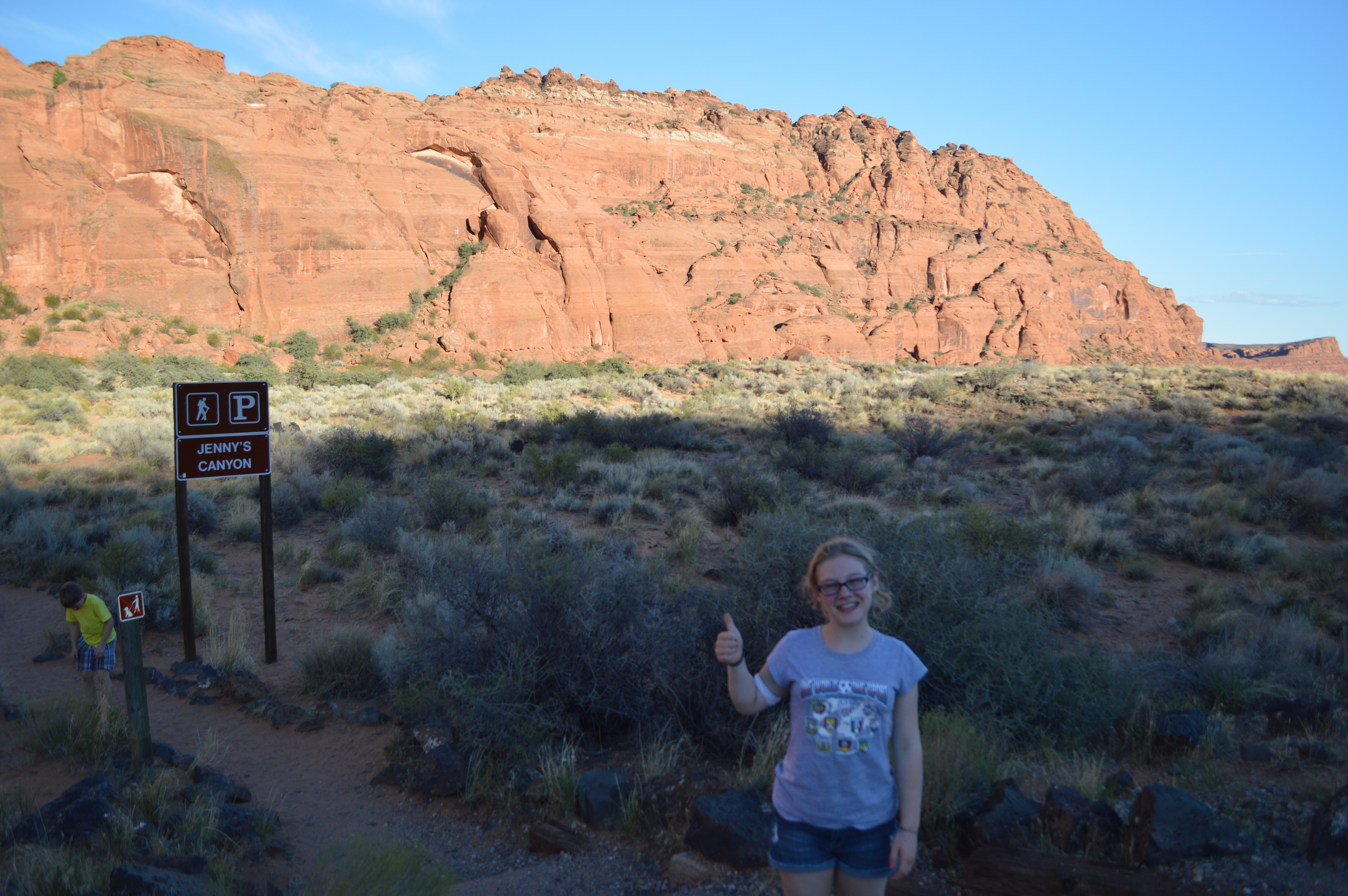
We paid for a day pass and collected a trail map. The very first trailhead promised a short hike ending in a small slot canyon, Jenny’s Canyon, it turned out. Taking our first steps into the fine red sand of the Utah desert was a queer thing. Such a different terrain than we had grown accustomed to. And rather than a trail winding through a corridor of trees, the desert and the sky spread out on all sides, giving you an unobstructed view of the horizon line nearly all the time. Ivan stopped to sift the sand through his fingers, and Veronica walked confidently ahead of the us, undaunted. How wonderfully bold children are. I was unnerved by the landscape, and overly-awed by the orange of the rock, the blue of the sky, the dryness of the air. I took photos and ambled along.
The slot canyon was cool inside, and had good outcroppings for climbing. We also found a good spot to shout and hear our voices echo off the walls of the cliffs. After messing around for a while, we headed back to the car. We drove another mile or so to a trailhead marked Petrified Sand Dunes. And so they were. The rich red sand Ivan had let run through his fingers was here frozen into rolling mounds of variegated rock. A short trail led into the slick rock where you could easily climb, and scramble if necessary, as far as the eye could see. Eventually, we crossed a rise with a small, steep canyon on the backside. The sun was setting, and the wind was arid and steady. The only family we had passed in the parking area were out of sight, so we were quite alone up there. Adam sat to meditate, and so we sat, Veronica and Ivan and I, looking down on the canyon filled with sage and Juniper trees. A blue scrub jay swooped into the canyon and disappeared amongst the trees. It took my breath away. I put my arms around the children and hoped they would remember this moment. It’s rare, but I felt for a moment, in bringing them to a place of such rare and splendid beauty, like a good mom. It was my favorite Sunday hike so far.


That more or less sums it up.
Isn’t this map beautiful though? I love the gentle dip and curve of the river, coursing through the grid of streets.
 The same area is mapped in below, in a 1906 map from The New Encyclopedic Atlas and Gazetteer of the World.
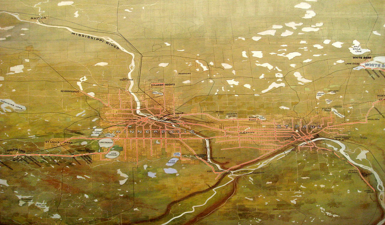
 And again in this beautiful commissioned watercolor map done by John Jager for the Twin Cities Rapid Transit Company in 1904.
 Finally, this map shows the area from quite a different angle. The image is from a flyby, a visual representation “as seen by the Landsat Thematic Mapper (TM) instrument. The shortwave infrared (TM band 5), infrared (TM band 4), and visible green (TM band 2) channels are displayed in the images as red, green, and blue respectively. In this combination, barren and/or recently cultivated land appears red to pink, vegetation appears green, water is dark blue, and artificial structures of concrete and asphalt appear dark grey or black.”
 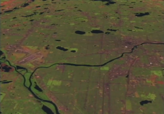 There is the video from which this is taken. It’s fascinating. Thanks NASA, you’re rad.


Hiking each week is easy, relative to writing about the hike. Hence the great delay.
We drove to River Falls to pick up an old friend of Adam’s, a fellow Buddhist, and he took us on a hike in the dense and mostly deciduous woods that hug the banks of the Kinnickinnic River. The woods are, as woods go, unremarkable. But that name! The rhythmic clack of it: Kinnickinnic, Kinnickinnic, Kinnickinnic. Like a train.
The walk itself was trying, for the kids and I. The trail was hilly. It spilled downhill to the muddy banks of the river, which smelled cool and sparkled in dappled sunlight, then wound back up into the still, humid green of the forest. And the it did that again.
Adam and his friend strode ahead. The kids grew weary, and so did I. The trail was narrow, and the woods were close, and it was all quite sticky. But we were good humored enough about it. We came to a clearing at the top of one hill, and the path opened up to a park. As we rounded a corner, Adam was hugging his friend, smiling, and saying how glad he was of something or another. I didn’t want to eavesdrop. But the hug and the gladness both being achieved, I took that as a signal to loop back to the car.
We dropped Adam’s friend back at his house, and had lunch at a small diner in downtown River Falls. We learned that truly, one man’s taco salad is another man’s nachos. Sated, we drove on to Menomonie, Wisconsin. (another good name) One of my oldest friends, Sarah, lives there with her family, in an idyllic farmhouse on a bucolic piece of land that that backs up to a river. We celebrated her son Rowan’s tenth birthday, and he opened our gift to him, which was cake tips and pastry bags, and we ate Sarah’s amazing food, and cheesecake, and went for a short walk down the road with the dogs. We left the kids with them, they were having a summer visit for a few days, leaving Adam and I to drive alone, westward in the fading light. Spent, we listened to poetry and spoke little.


